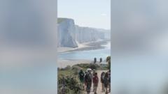
The King Charles III England Coast Path represents the transition of public rights of way from a fragmented, local-interest network into a singular, national infrastructure asset. At 2,700 miles (approximately 4,345 kilometers), it is the longest continuous coastal walking route globally, yet its significance lies not in its linear distance but in its legal and economic framework. Unlike traditional footpaths, which often rely on static easements, this project utilizes a "rolling margin" legal mechanism. This ensures that as coastal erosion occurs—a certainty given the UK's geomorphology—the path migrates inland automatically, maintaining the integrity of the asset without requiring constant legislative renegotiation.
The Triad of Coastal Utility
The development of this path serves three distinct functions that traditional tourism reporting often conflates: the preservation of the "right to roam," the mitigation of coastal environmental risks, and the stimulation of micro-economies in peripheral maritime regions.
- Legal Resilience (The Rolling Margin): Under the Marine and Coastal Access Act 2009, the path creates a "coastal margin." This includes the trail itself and a wider area of land—often down to the mean low-water mark—where the public has a right of access for recreation. The innovation here is the decoupling of the path from fixed GPS coordinates. As cliffs recede, the trail shifts. This creates a permanent public asset that is immune to the physical volatility of the coastline.
- Economic Dispersal: British tourism is historically centralized in urban hubs or established parks like the Lake District. This path forces a "long-tail" distribution of visitor spending. By connecting obscure coastal villages to a high-visibility national brand, the infrastructure lowers the barrier to entry for small-scale hospitality and service providers in economically stagnant regions.
- Physical and Mental Health Externalities: The UK government quantifies the value of coastal access through the "Social Value" of physical activity. By providing a low-cost, high-accessibility venue for long-distance transit and short-form recreation, the path functions as a preventative health measure, potentially reducing long-term strain on the National Health Service (NHS).
Structural Dynamics of Trail Completion
The completion of the path is not a singular event but a phased activation of diverse coastal segments. Each segment faces unique "friction points" that dictate the speed of rollout and the eventual quality of the user experience.
The Friction of Land Tenure
England’s land ownership is a complex mosaic of private estates, Ministry of Defence (MoD) training ranges, and sensitive industrial sites (such as nuclear power stations at Hinkley Point or Sizewell). The path must negotiate these "bottlenecks." In many cases, the path uses seasonal diversions or permanent inland detours. The success of the trail depends on minimizing these deviations; every mile diverted inland away from the sea reduces the premium value of the coastal experience.
Environmental Sensitivity vs. Throughput
Coastal zones are often protected as Sites of Special Scientific Interest (SSSI) or Special Areas of Conservation (SAC). High footfall can lead to soil compaction, disruption of nesting birds, and the introduction of invasive species. The management strategy employs "spreading room" to diffuse the impact. Rather than a narrow, beaten track, the coastal margin allows walkers to disperse across wider areas where ecologically viable, preventing the "trenching" effect seen on popular mountain routes like the Pennine Way.
Quantifying the Socio-Economic Impact
To assess the true value of the King Charles III England Coast Path, one must move beyond "number of walkers" and look at "dwell time" and "spend per mile."
- The Multiplier Effect: Research into existing National Trails, such as the South West Coast Path, indicates that for every £1 invested in path maintenance, there is an estimated £2 to £3 return to the local economy. This is driven primarily by overnight stays. Long-distance hikers require a "service chain" of accommodation, luggage transfer, and calorie replenishment every 12 to 15 miles.
- Asset Liquidity: A continuous path has higher "liquidity" than a fragmented one. A walker is more likely to commit to a 100-mile stretch if they are certain of a contiguous, well-marked route. The "King Charles III" branding acts as a quality assurance stamp, reducing the "information search cost" for international and domestic tourists.
Engineering for the Anthropocene
The path is a rare example of infrastructure designed for a changing climate. The UK's East Coast is currently subsiding while the West Coast is slowly rising due to post-glacial isostatic rebound. Furthermore, rising sea levels and increased storm frequency accelerate erosion rates in soft-sediment areas like Holderness or parts of Norfolk.
Adaptation Strategies
The path's design avoids "hard" engineering (concrete sea walls) which often exacerbates erosion elsewhere. Instead, it utilizes "soft" management.
- Natural Capital Realignment: By allowing the path to move, the government avoids the prohibitive costs of defending unsustainable coastlines.
- Permeable Boundaries: Using natural boundaries like hedgerows or drainage ditches instead of rigid fencing allows the ecosystem—and the path—to breathe.
Barriers to Global Scalability
While the England Coast Path is a masterclass in coastal management, its model is not easily exported to nations with different legal traditions.
- The Right of Public Access: England’s "right to roam" culture (formalized in the CRoW Act 2000) provides the political capital for such a project. In countries with absolute private property rights (e.g., the United States), a 2,700-mile contiguous path would be legally impossible without massive eminent domain litigation.
- Maintenance Liability: A 2,700-mile asset requires an astronomical maintenance budget. In the UK, this is distributed between Natural England and local authorities. The risk is "deferred maintenance," where bridges, signage, and surfaces degrade, leading to "asset strandedness" where sections become impassable, breaking the continuity that gives the path its value.
Strategic Implementation for Local Economies
For local stakeholders, the path is not a "build it and they will come" scenario. It is a catalyst that requires proactive regional strategy.
- Nodal Development: Towns positioned at natural 15-mile intervals should prioritize "hiker-friendly" infrastructure: lockers, drying rooms, and reliable public transport links back to major rail hubs.
- Digital Integration: The physical path must be mirrored by a digital twin. Accurate, real-time data on path closures (due to tides, erosion, or land management) is essential. Relying on paper maps or static PDFs is a failure of service delivery in a modern tourism market.
- Seasonal Flattening: The path’s primary economic value is its ability to extend the tourism season. Coastal towns are often "ghost towns" in October or March. Robust, all-weather path infrastructure allows for "shoulder season" hiking, stabilizing employment in the hospitality sector.
The King Charles III England Coast Path is a sophisticated response to the competing demands of environmental conservation, public health, and rural economic development. Its success will be measured not by the ribbon-cutting of its final mile, but by the longevity of the businesses it supports and the durability of its rolling margin in the face of an encroaching sea.
Local government authorities should immediately audit their "last mile" connectivity between the trail and local rail stations. Without a seamless transition from transit hub to trailhead, the path remains a localized asset rather than a national economic engine. Priority should be given to creating high-density, low-impact accommodation clusters every 10 to 12 miles to capture the maximum spend from the long-distance demographic.


-Boeing-777-337(ER)-VT-ALN.jpg)
